Get a clear picture of the risks and complexities of projects involving rock and soil slopes.
Apply multiple analysis methods and make better decisions with all the data consolidated in a visible model.
Design more effective solutions and optimise engineering efforts using intuitive workflows.
Analyse slope stability projects with SLOPE/W
Evaluate a full range of stability problems to improve safety of excavations, slopes, and embankments
Go to storeTry it nowSLOPE/W is the leading slope stability software for soil and rock slopes
Explore almost any stability problem
Designed for a large variety of projects to analyse stability problems for soil and rock slopes, construction and excavations, dams and levees, open-pit highwalls, tailings dams and more.
Make safer design decisions based on thorough analysis of slip surface shapes, pore-water pressure conditions, soil properties, and loading conditions.
Design and engineer for safety
Harness powerful analysis capability and test scenarios by changing condition parameters and definitions. Allow the rigorous solution algorithm to display difficult problems close up.
Build a clear picture of typical conditions, explore variables and design optimal stabilisation and reinforcement options that meet code requirements.
Intuitive workflows for model building
Generate your analysis model using intuitive workflows. Create, import, define, solve, and visualise slip surface details, then generate plots and reports.
Integrate data from other programs such as SEEP/W, SIGMA/W and QUAKE/W to enhance the big picture and enable parallel analysis.
SLOPE/W is part of GeoStudio integrated geo-engineering software
GeoStudio Stories

GeoStudio Answer Hour: New Features in GeoStudio
GeoStudio 2024.1 continues to build on Seequent’s geotechnical analysis solution, with the addition of many…

Integrate, communicate, and interpret geotechnical data
with industry-leading geo-engineering numerical modelling
Try it nowKey features

Integrate pore-water pressure data
Define pore-water pressures using piezometric lines, spatial functions, and import results from other finite element analyses. Display values as contours on the geometry.

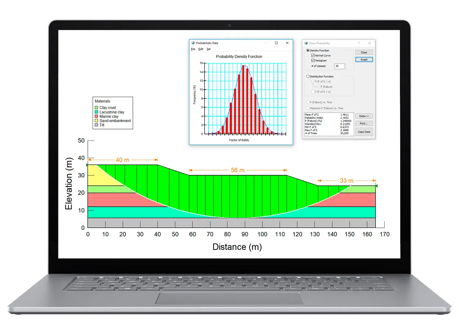
Perform multiple rapid drawdown analysis
Complete a rapid drawdown analysis several ways, including with pore-water pressures data, transient finite element analysis, or the multi-stage rapid drawdown technique.

Run concurrent slope stability analysis
Define slope materials using built-in models and add-in functions, then run concurrent analyses, such as finite element stress analysis and limit equilibrium to analyse almost any slope stability problem.
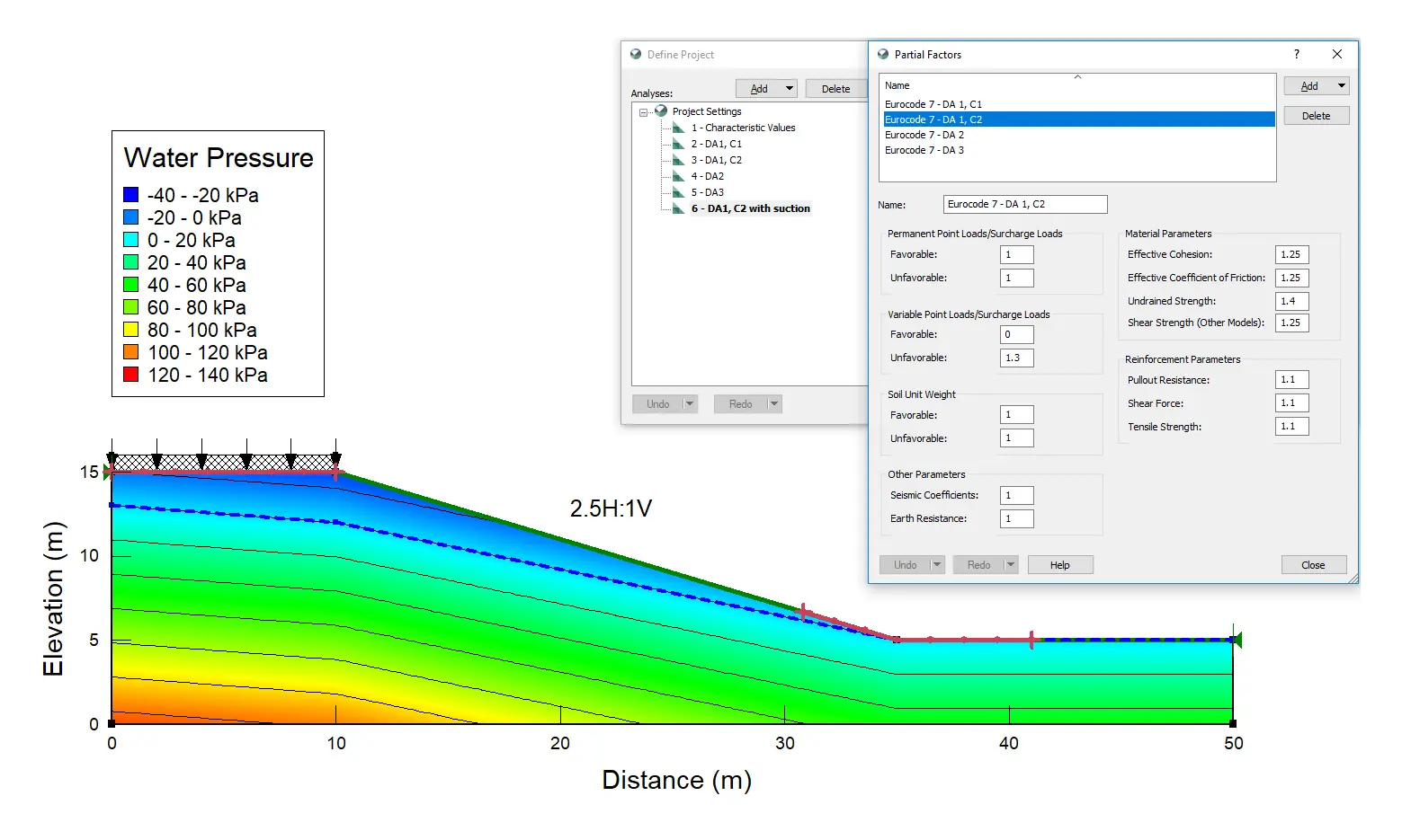
Apply limit state design methods
Apply the limit state design or load and resistance factor methodology by specifying partial factors on permanent/variable loads, seismic coefficients, material properties, reinforcement inputs, and more.

Overcome complex non-linear problems
Generate a graphical display of the Factor of Safety vs Lambda plot to inspect the acceptability of convergence for highly non-linear problems with difficult convergence.
Useful Information
System Requirements
We recommend you use Windows 10, with a reasonably fast processor, mid range graphics and 32GB of system memory.
Supported Data/Formats
Supported kinds of data and formats that you can use with Leapfrog Geo.